MURTAZIN ERMEK
Deputy Director for Science, candidate of geological and mineralogical sciences
The purpose of the program:
Based on FAO’s 2018 findings (UN Food and Agriculture Organization), the annual global volume of groundwater extraction for irrigated agriculture is estimated to be 820 km3. This represents a 19 percent rise compared to the 2010 estimate of 688 km3. The portion of freshwater abstraction used for irrigated agriculture from groundwater is over 30 percent, and it continues to increase at a rate of approximately 2.2 percent annually.
By adopting integrated water resources management approaches that combine both groundwater and surface water sources, the vulnerability of communities to extreme climate events and changes can be substantially reduced. Moreover, such approaches can contribute to enhanced water and food security. Utilizing aquifers as natural reservoirs (using managed aquifer recharge systems or MAR systems) provides several advantages, including the avoidance of issues associated with evaporation losses and the adverse impacts on ecosystems that are often associated with large-scale, man-made surface water reservoirs.
Program objectives:
- Generalization and analysis of factual data, archive and analytical materials on the peculiarities of the formation of exploitable reserves of groundwater deposits in Kazakhstan, explored for land irrigation purposes.
- Regional expeditionary research to assess the current state of groundwater deposits in Kazakhstan, explored for land irrigation purposes.
- Analysis and assessment of trends in changes in storage and renewable resources of groundwater deposits in Kazakhstan, explored for land irrigation purposes, under the influence of climatic factors and anthropogenic pressures.
- Analysis and assessment of the availability, condition and prospects of groundwater using for ensuring sustainable irrigated agriculture in Kazakhstan.
- Creating of a database of groundwater deposits in Kazakhstan, explored for land irrigation purposes, assessment of their resource potential for sustainable irrigated agriculture.
- Development and creation of a geoinformation-analytical subsystem of exploitable reserves of groundwater deposits in Kazakhstan, explored for irrigation, to assessment, forecasting and management decisions on their use and protection for sustainable irrigated agriculture.
Measurable indicators of problem-solving outcomes include:
- Assessment of the unique characteristics, conditions of formation, and security of explotable reserves in 115 groundwater deposits in Kazakhstan explored for land irrigation. These assessments will be conducted across 5 state regions, 8 water management basins, and 17 administrative provinces.
- Regional studies will be carried out in the 17 administrative provinces of Kazakhstan to evaluate the current state of the 115 groundwater deposits explored for land irrigation. The objective of studies is to identify negative processes resulting from anthropogenic and natural-climatic impacts that affect the explotable groundwater reserves.
- Analysis and evaluation of trends in changes related to the natural (storage) reserves and renewable resources of the 115 groundwater well fields in Kazakhstan explored for land irrigation. This assessment considers the influence of climatic factors and anthropogenic pressures.
- Analysis and evaluation of the availability, status, and future prospects for the sustainable use of groundwater reserves in the 115 fields for irrigated agriculture in Kazakhstan. This analysis was conducted at regional (17 administrative provinces, 5 regions), basin (8 water management basins), and national (Republic of Kazakhstan) levels, with a focus on the year 2050.
- Formation of databases for the 115 groundwater well fields in Kazakhstan that have been explored for irrigated agriculture.
- Assessment of the resource potential of the 115 groundwater deposits in Kazakhstan, specifically explored for irrigated lands, with regards to sustainable irrigated agriculture. This assessment covers 5 regions, 8 water management basins, and 17 administrative provinces.
- Development and creation of a geo-informational and analytical subsystem that focuses on the explotable groundwater reserves of the 115 groundwater deposits in Kazakhstan explored for irrigation lands. This subsystem enables assessment, forecasting, and decision-making processes for the use and protection of these reserves, promoting sustainable irrigated agriculture.
Scientific novelty and significance of the program
The 6th UN Sustainable Development Goal is to ensure the availability and rational use of water resources and sanitation for all by 2030, has been established. The total global freshwater reserves are estimated to be approximately 35 million km3, with groundwater accounting for 30.1% (10.5 million km3) of this total. In contrast, freshwater reserves in rivers and reservoirs constitute less than 0.5% [1]. Due to the scarcity of fresh surface water, many countries are now relying on groundwater resources. Groundwater offers several advantages over surface water. Firstly, it generally exhibits better quality, increased protection against pollution and contamination, and reduced susceptibility to seasonal and multi-year fluctuations. Moreover, in most cases, the use of groundwater does not require expensive water treatment measures.
In the past 25-30 years, global drilling activities for groundwater extraction have resulted the creation of more than 300 million wells. The annual worldwide withdrawal of groundwater reached an estimated 959 km3 (equivalent to over 30,000 m3/s) as of 2017, with Asia being responsible for 68.5% of this total. Within Asia, eight out of the top ten countries with the highest proportion of groundwater abstraction (accounting for 75% of the total volume) are located. These countries, listed in descending order, are India, China, Pakistan, Iran, Indonesia, Bangladesh, Saudi Arabia, and Turkey. Notably, in Asia, 76% of the withdrawn groundwater is utilized for agricultural purposes, specifically for regular irrigation.
Integrated water resources management approaches that integrate groundwater and surface water can significantly reduce human vulnerability to extreme climate events and changes, and contribute to enhanced water and food security. According to expert estimates, the joint use of groundwater and surface water, where surface water is used for irrigation and water supply during wet periods and groundwater during drought periods, is of paramount importance. The existing uncertainties in water resource forecasts and the longer (century-long) accumulation of fresh water in aquifers play an important role in setting and implementing sustainable development goals. The use of aquifers as natural reservoirs avoids many of the problems associated with evaporation losses and impacts on ecosystems that are caused by large and man-made surface reservoirs.
Further research is necessary to unveil the intricate connection between groundwater availability, ecosystem health, and groundwater management policies to prevent regional land degradation. The desertification process in extensive areas of Kazakhstan is accompanied by various detrimental effects such as soil contamination, waterlogging from both surface and groundwater sources, soil salinization, erosion caused by water and wind, deterioration of vegetation cover, desiccation, and the overall decline in the region's ecological capacity.
The projected water demand rise attributed to climate change primarily stems from the expansion of agricultural and landscape irrigation activities, driven by the escalating potential evapotranspiration rates. Modeling studies indicate that the Central Asian region is expected to reach peak water usage around 2050, followed by a significant decline in runoff. This shift will lead to a heightened occurrence of extreme floods and droughts, exacerbating overall water scarcity issues.
The sustainable development of the economy in Kazakhstan and the well-being of its population heavily rely on the availability and quality of water resources. The total average multi-year runoff from rivers and temporary streams, considering the current water withdrawals by the People's Republic of China from the Ertis and Ile Rivers, is estimated to be 100.58 km3. Within this estimate, approximately 55.94 km3 (55.6%) is generated within Kazakhstan's borders, while the remaining 44.64 km3 (44.4%) originates from outside the country. The distribution of surface water resources across the nation is highly uneven and subject to significant year-to-year and seasonal variability in volume. The transit river basins, namely Ertis, Ile, Syrdarya, and Zhaiyk, receive the majority of water resources. However, the Mangistau region experiences negligible local surface runoff.
Disposable water resources are of significant importance as they determine the potential utilization of river flow in various economic sectors. Their value is calculated by considering the disparity between water resources and the obligatory costs associated with runoff. These costs encompass mandatory releases to neighboring countries, evaporation and filtration losses, environmental sanitary releases to downstream areas, and other forms of loss. Looking ahead, the projected available water resources for Kazakhstan are as follows: in dry years, it is estimated to be 10 km3 by 2030 and 9.9 km3 by 2040; in average water years, the figures are 20.4 km3 by 2030 and 23.1 km3 by 2040; in high water years, it is anticipated to be 30 km3 by 2030 and 29.7 km3 by 2040.
The uneven distribution of surface water resources across the country, particularly those suitable for utilization, leads to a shortage of freshwater. This deficit can be addressed through the prudent exploitation of groundwater resources, which are characterized by higher quality, greater protection against pollution, and wider distribution. Consequently, groundwater serves as a crucial mineral resource for Kazakhstan and plays a strategic role in ensuring water security.
Through extensive scientific research, the scientists at the Akhmedsafin Institute of Hydrogeology and Environmental Geoscience have uncovered the fundamental patterns governing the formation and distribution of groundwater resources within the depths of Kazakhstan. The country is blessed with abundant groundwater reserves. According to assessments by local hydrogeologists, the natural (storage) stocks of groundwater in Kazakhstan exceed 2600 km3, which is 26 times greater than the average annual volume of river runoff or 58 times larger than the volume of river runoff generated within the country. The resource potential of the country's groundwater is evaluated based on both predicted resources, representing the potential use of groundwater, and explotable reserves identified at specific locations. The methodology employed to estimate the predicted resources of groundwater in Kazakhstan aims to determine the potential volume of groundwater extraction in hydrogeological regions, river basins, administrative areas, and other geographical units. The ratio of operational groundwater reserves to the predicted resources of a particular hydrogeological structure serves as an indicator of its level of exploration .
The cumulative volume of groundwater resources with a salinity level of up to 10 g/L amounts to 64 km3 per year. This includes freshwater (up to 1.0 g/L) accounting for 40.4 km3 per year and slightly saline water (1.0-3.0 g/L) equal to 16.4 km3 per year. As a whole, the projected resources of freshwater and brackish groundwater are estimated at 56.8 km3 per year, which is comparable to the average annual local surface runoff and surpasses the availability of surface water resources for utilization.
The assessment of the viability of utilizing groundwater resources relies on data concerning their operational reserves, which define their significance as a mineral resource. Within the country's borders, there exist over 4000 examined deposits and groundwater areas, with exploitable reserves estimated at approximately 15 km3 per year, corresponding to an exploration level of about 37%. The hydrogeological characteristics of the Republic have resulted in an uneven territorial distribution of fresh groundwater reserves. Consequently, around 50% of the resources are concentrated in the southern regions, while 30% are found in the central, northern, and eastern areas, and less than 20% are situated in the west.
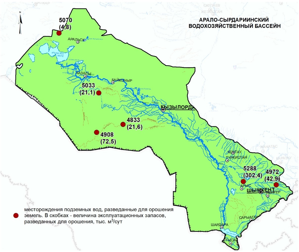
During the 1970s and 1980s, approximately 115 groundwater deposits and sites were explored and investigated in Kazakhstan for the purpose of irrigating state-owned lands. These locations possess a combined exploitable reserve of 7.8 km3 per year or 247.2 m3/s, which accounts for over 50% of the total reserves. The distribution of these reserves across the country's regions is uneven, with the Southern region containing 64.6%, the Eastern region comprising 15.5%, the Northern region encompassing 14.8%, the Western region representing 3.1%, and the Central region constituting 2.0%.
According to the Committee on Water Resources of the Ministry of Ecology and Natural Resources of the Republic of Kazakhstan, the annual groundwater abstraction in the past decade ranged from 1.02 to 1.08 km3, accounting for 3.7-5.0% of the total annual water intake in the country. This withdrawal represents approximately 7% of the exploitable groundwater reserves. In terms of agricultural water supply, approximately 0.15-0.21 km3/year of groundwater is withdrawn, which corresponds to 8-15% of the total annual withdrawal. Out of this amount, only 0.02-0.009 km3/year is allocated for regular irrigation. Consequently, the resource potential of groundwater remains largely untapped in the agricultural sector. These figures highlight the relatively low use of groundwater resources in Kazakhstan compared to developed countries in Europe and Asia. It is necessary to note the ongoing project of the European Bank for Reconstruction and Development on the rehabilitation of 264 canals and 46 groundwater wells in the Zhambyl administrative region of Kazakhstan to increase the area of irrigated lands.
The limited availability of specific studies on groundwater currently hinders the understanding of the dynamic relationship between groundwater and its potential for irrigation.
Water shortage is highlighted among the main global challenges in the “Kazakhstan 2050 Strategy”. The need to improve the efficiency of use and protection of water resources is noted in the list of the state tasks of the 6th Policy – “Green” economy and environmental protection of the Strategic Development Plan of the Republic of Kazakhstan until 2025. The research results are relevant for ensuring water security in Kazakhstan in dry periods providing the existence of transboundary threats to reduce available surface water resources and further sustainable social and economic development of the country. The results of the Program will contribute to the implementation of the tasks of the General Scheme for the Organization of the Territory of the Republic of Kazakhstan, the Strategic Development Plan of the Republic of Kazakhstan until 2025, Kazakhstan 2050 Strategy: a new political course of the established state, the General Scheme for the Integrated Use and Protection of Water Resources, the National Projects – “Green Kazakhstan” and “Technological breakthrough through digitalization, science and innovation”.
The 6th UN Sustainable Development Goal is to ensure the availability and rational use of water resources and sanitation for all by 2030, has been established. The total global freshwater reserves are estimated to be approximately 35 million km3, with groundwater accounting for 30.1% (10.5 million km3) of this total. In contrast, freshwater reserves in rivers and reservoirs constitute less than 0.5% [1]. Due to the scarcity of fresh surface water, many countries are now relying on groundwater resources. Groundwater offers several advantages over surface water. Firstly, it generally exhibits better quality, increased protection against pollution and contamination, and reduced susceptibility to seasonal and multi-year fluctuations. Moreover, in most cases, the use of groundwater does not require expensive water treatment measures.
In the past 25-30 years, global drilling activities for groundwater extraction have resulted the creation of more than 300 million wells. The annual worldwide withdrawal of groundwater reached an estimated 959 km3 (equivalent to over 30,000 m3/s) as of 2017, with Asia being responsible for 68.5% of this total. Within Asia, eight out of the top ten countries with the highest proportion of groundwater abstraction (accounting for 75% of the total volume) are located. These countries, listed in descending order, are India, China, Pakistan, Iran, Indonesia, Bangladesh, Saudi Arabia, and Turkey. Notably, in Asia, 76% of the withdrawn groundwater is utilized for agricultural purposes, specifically for regular irrigation.
Integrated water resources management approaches that integrate groundwater and surface water can significantly reduce human vulnerability to extreme climate events and changes, and contribute to enhanced water and food security. According to expert estimates, the joint use of groundwater and surface water, where surface water is used for irrigation and water supply during wet periods and groundwater during drought periods, is of paramount importance. The existing uncertainties in water resource forecasts and the longer (century-long) accumulation of fresh water in aquifers play an important role in setting and implementing sustainable development goals. The use of aquifers as natural reservoirs avoids many of the problems associated with evaporation losses and impacts on ecosystems that are caused by large and man-made surface reservoirs.
Further research is necessary to unveil the intricate connection between groundwater availability, ecosystem health, and groundwater management policies to prevent regional land degradation. The desertification process in extensive areas of Kazakhstan is accompanied by various detrimental effects such as soil contamination, waterlogging from both surface and groundwater sources, soil salinization, erosion caused by water and wind, deterioration of vegetation cover, desiccation, and the overall decline in the region's ecological capacity.
The projected water demand rise attributed to climate change primarily stems from the expansion of agricultural and landscape irrigation activities, driven by the escalating potential evapotranspiration rates. Modeling studies indicate that the Central Asian region is expected to reach peak water usage around 2050, followed by a significant decline in runoff. This shift will lead to a heightened occurrence of extreme floods and droughts, exacerbating overall water scarcity issues.
The sustainable development of the economy in Kazakhstan and the well-being of its population heavily rely on the availability and quality of water resources. The total average multi-year runoff from rivers and temporary streams, considering the current water withdrawals by the People's Republic of China from the Ertis and Ile Rivers, is estimated to be 100.58 km3. Within this estimate, approximately 55.94 km3 (55.6%) is generated within Kazakhstan's borders, while the remaining 44.64 km3 (44.4%) originates from outside the country. The distribution of surface water resources across the nation is highly uneven and subject to significant year-to-year and seasonal variability in volume. The transit river basins, namely Ertis, Ile, Syrdarya, and Zhaiyk, receive the majority of water resources. However, the Mangistau region experiences negligible local surface runoff.
Disposable water resources are of significant importance as they determine the potential utilization of river flow in various economic sectors. Their value is calculated by considering the disparity between water resources and the obligatory costs associated with runoff. These costs encompass mandatory releases to neighboring countries, evaporation and filtration losses, environmental sanitary releases to downstream areas, and other forms of loss. Looking ahead, the projected available water resources for Kazakhstan are as follows: in dry years, it is estimated to be 10 km3 by 2030 and 9.9 km3 by 2040; in average water years, the figures are 20.4 km3 by 2030 and 23.1 km3 by 2040; in high water years, it is anticipated to be 30 km3 by 2030 and 29.7 km3 by 2040.
The uneven distribution of surface water resources across the country, particularly those suitable for utilization, leads to a shortage of freshwater. This deficit can be addressed through the prudent exploitation of groundwater resources, which are characterized by higher quality, greater protection against pollution, and wider distribution. Consequently, groundwater serves as a crucial mineral resource for Kazakhstan and plays a strategic role in ensuring water security.
Through extensive scientific research, the scientists at the Akhmedsafin Institute of Hydrogeology and Environmental Geoscience have uncovered the fundamental patterns governing the formation and distribution of groundwater resources within the depths of Kazakhstan. The country is blessed with abundant groundwater reserves. According to assessments by local hydrogeologists, the natural (storage) stocks of groundwater in Kazakhstan exceed 2600 km3, which is 26 times greater than the average annual volume of river runoff or 58 times larger than the volume of river runoff generated within the country. The resource potential of the country's groundwater is evaluated based on both predicted resources, representing the potential use of groundwater, and explotable reserves identified at specific locations. The methodology employed to estimate the predicted resources of groundwater in Kazakhstan aims to determine the potential volume of groundwater extraction in hydrogeological regions, river basins, administrative areas, and other geographical units. The ratio of operational groundwater reserves to the predicted resources of a particular hydrogeological structure serves as an indicator of its level of exploration .
The cumulative volume of groundwater resources with a salinity level of up to 10 g/L amounts to 64 km3 per year. This includes freshwater (up to 1.0 g/L) accounting for 40.4 km3 per year and slightly saline water (1.0-3.0 g/L) equal to 16.4 km3 per year. As a whole, the projected resources of freshwater and brackish groundwater are estimated at 56.8 km3 per year, which is comparable to the average annual local surface runoff and surpasses the availability of surface water resources for utilization.
The assessment of the viability of utilizing groundwater resources relies on data concerning their operational reserves, which define their significance as a mineral resource. Within the country's borders, there exist over 4000 examined deposits and groundwater areas, with exploitable reserves estimated at approximately 15 km3 per year, corresponding to an exploration level of about 37%. The hydrogeological characteristics of the Republic have resulted in an uneven territorial distribution of fresh groundwater reserves. Consequently, around 50% of the resources are concentrated in the southern regions, while 30% are found in the central, northern, and eastern areas, and less than 20% are situated in the west.
During the 1970s and 1980s, approximately 115 groundwater deposits and sites were explored and investigated in Kazakhstan for the purpose of irrigating state-owned lands. These locations possess a combined exploitable reserve of 7.8 km3 per year or 247.2 m3/s, which accounts for over 50% of the total reserves. The distribution of these reserves across the country's regions is uneven, with the Southern region containing 64.6%, the Eastern region comprising 15.5%, the Northern region encompassing 14.8%, the Western region representing 3.1%, and the Central region constituting 2.0%.
According to the Committee on Water Resources of the Ministry of Ecology and Natural Resources of the Republic of Kazakhstan, the annual groundwater abstraction in the past decade ranged from 1.02 to 1.08 km3, accounting for 3.7-5.0% of the total annual water intake in the country. This withdrawal represents approximately 7% of the exploitable groundwater reserves. In terms of agricultural water supply, approximately 0.15-0.21 km3/year of groundwater is withdrawn, which corresponds to 8-15% of the total annual withdrawal. Out of this amount, only 0.02-0.009 km3/year is allocated for regular irrigation. Consequently, the resource potential of groundwater remains largely untapped in the agricultural sector. These figures highlight the relatively low use of groundwater resources in Kazakhstan compared to developed countries in Europe and Asia. It is necessary to note the ongoing project of the European Bank for Reconstruction and Development on the rehabilitation of 264 canals and 46 groundwater wells in the Zhambyl administrative region of Kazakhstan to increase the area of irrigated lands.
The limited availability of specific studies on groundwater currently hinders the understanding of the dynamic relationship between groundwater and its potential for irrigation.
Water shortage is highlighted among the main global challenges in the “Kazakhstan 2050 Strategy”. The need to improve the efficiency of use and protection of water resources is noted in the list of the state tasks of the 6th Policy – “Green” economy and environmental protection of the Strategic Development Plan of the Republic of Kazakhstan until 2025. The research results are relevant for ensuring water security in Kazakhstan in dry periods providing the existence of transboundary threats to reduce available surface water resources and further sustainable social and economic development of the country. The results of the Program will contribute to the implementation of the tasks of the General Scheme for the Organization of the Territory of the Republic of Kazakhstan, the Strategic Development Plan of the Republic of Kazakhstan until 2025, Kazakhstan 2050 Strategy: a new political course of the established state, the General Scheme for the Integrated Use and Protection of Water Resources, the National Projects – “Green Kazakhstan” and “Technological breakthrough through digitalization, science and innovation”.
EXPECTED AND ACHIEVED RESULTS:
main results for 2023:
The resource potential of groundwater deposits explored for land irrigation was assessed in 4 administrative regions of Western Kazakhstan (Aktobe, Atyrau, West Kazakhstan and Mangystau) and the Zhaiyk-Caspian water basin.
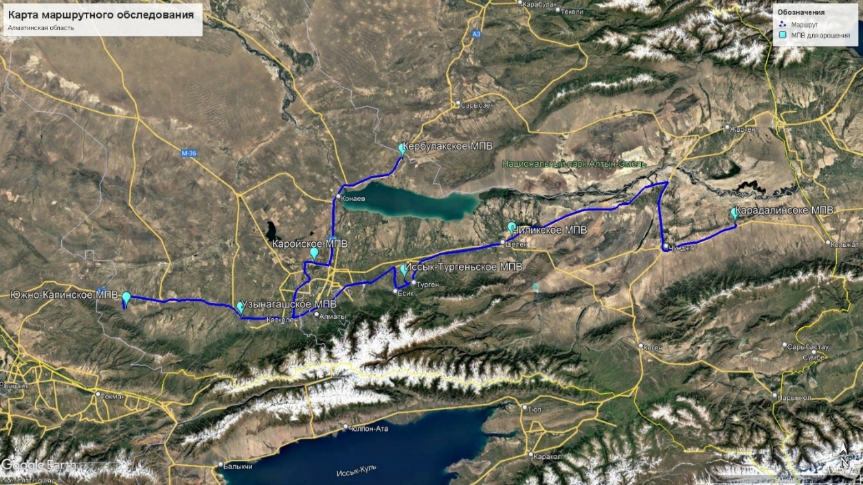
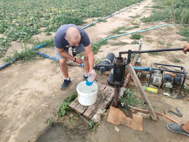
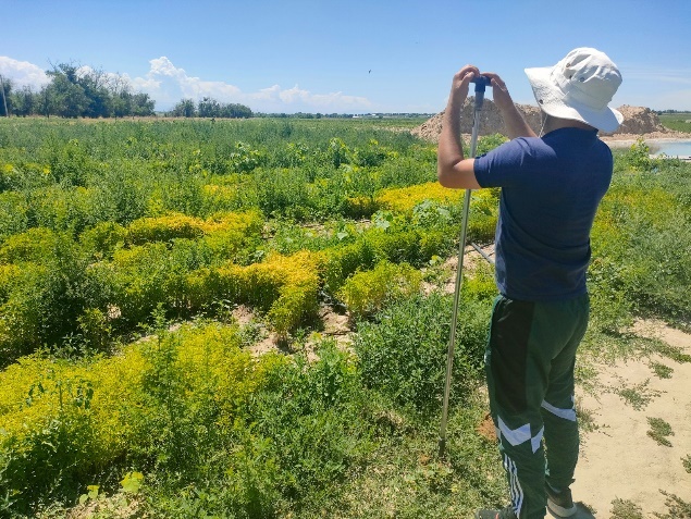
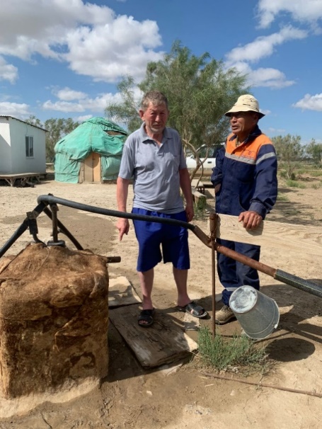
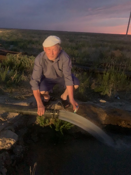
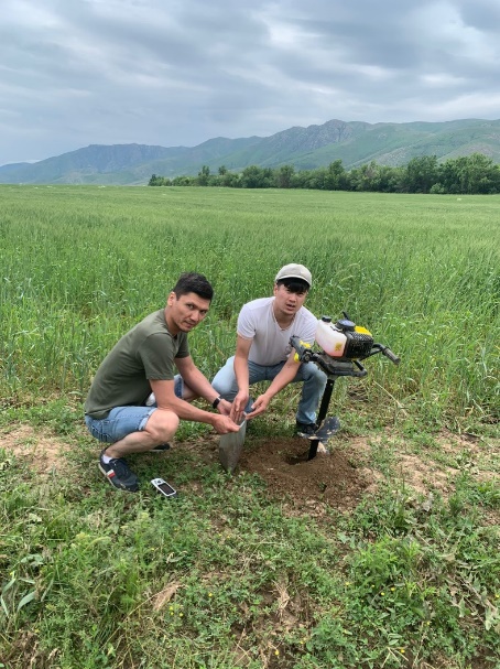
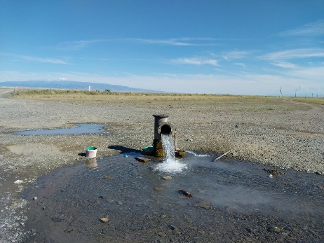
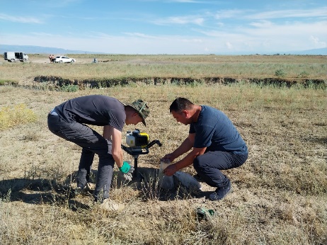
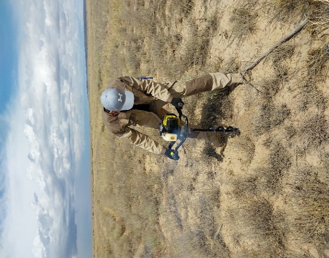
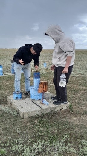
Regional expeditionary studies were carried out to assess the current state of groundwater deposits explored for land irrigation, with sampling of groundwater and soils for chemical and laboratory studies in 4 administrative regions of Western Kazakhstan and the Zhaiyk-Caspian water basin. Ground field surveys were carried out in November 2023 by 4 field teams within the Aktobe, Mangistau, Atyrau and West Kazakhstan regions. The total length of route surveys was up to 7777 km, 30 wells were examined and 23 water samples were taken, as well as 36 soil samples. In general, we can conclude that, from an ecological point of view, the condition of the groundwater deposit areas is in good condition. No subsidence of soils or ground surface was detected. There are no processes of soil salinization or oppression of flora. From a sanitary point of view, no probable foci of soil and groundwater contamination have been identified.
The total value of exploitable groundwater reserves in the Western region is estimated at 1.09 km3/year, including with mineralization up to 1 g/l – 0.60 km3/year. The region's exploration of fresh groundwater is 22.7%. For the purpose of land irrigation, 8 groundwater deposits have been explored with the value of operational reserves - 200.34 thousand m3/day.
A geoinformation and analytical subsystem (GIAS) of operational groundwater reserves of deposits in Western Kazakhstan, explored for irrigation, has been developed and created in order to assess, forecast and make management decisions on their use and protection for sustainable irrigated agriculture in 4 administrative regions (Aktobe, Atyrau, West -Kazakhstan and Mangystau) and Zhaiyk-Caspian water basin.
The system was filled with data from operational reserves of groundwater deposits in the administrative regions of Western Kazakhstan (Aktobe, Atyrau, West Kazakhstan and Mangistau) and the Zhaiyk-Caspian water basin. The system was created in ArcGIS. All information presented in GIAS is contained in semantic and graphical databases and a document database. An effective means of visualizing information is to present tabular information in the form of diagrams associated with certain territories on the map (regions, water basins, etc.). This forms the integrity of the idea of the studied object of the underground hydrosphere. The GIAS structure is not rigid and can be supplemented or changed in the process of solving practical hydrogeological problems. The results obtained correspond to the standards accepted for GIS. The content of GIAS satisfies all the requirements for the presentation of specialized hydrogeological information.
EXPECTED AND ACHIEVED RESULTS:
main results for 2024:
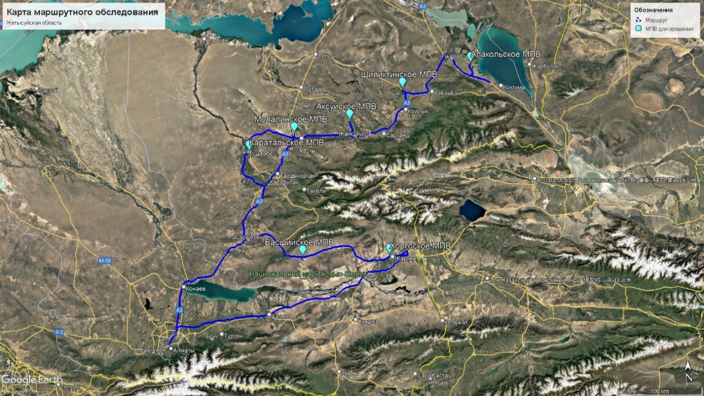
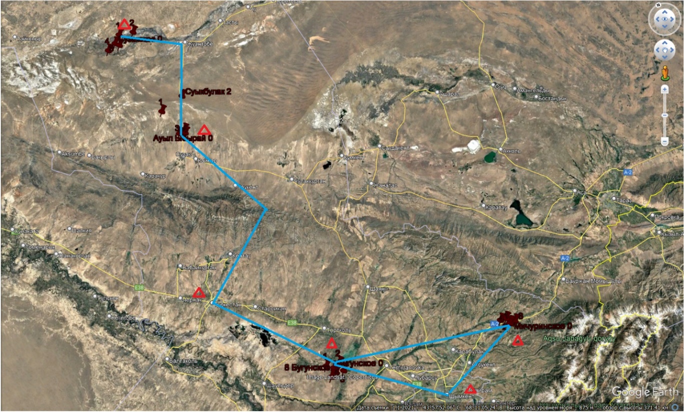
A generalisation and analysis of actual data, stock and analytical materials on the peculiarities of the formation of groundwater well fields operational reserves prospected for irrigation was carried out on three administrative provinces of Southern Kazakhstan, two administrative provinces of Eastern Kazakhstan and two administrative provinces of Central Kazakhstan, and three water management basins (WMB) (Shu-Talas, Balkash-Alakol and Nura-Sarysu).
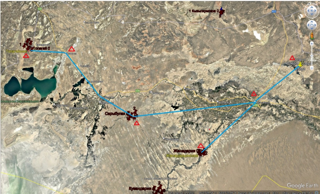
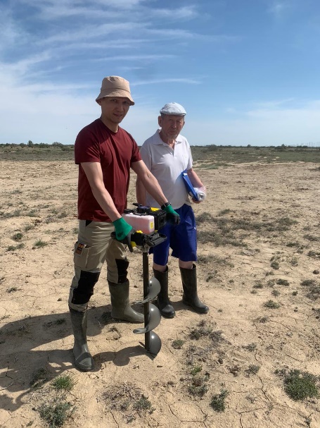
A series of regional expeditions were carried out to evaluate the present status of groundwater well fields that had been explored for irrigation purposes. These expeditions collected groundwater and soil samples for subsequent chemical and laboratory analysis. These samples were obtained from seven Southern and Eastern Kazakhstan administrative regions and three WMBs within the study area. The total length of route surveys was 19,220 km, 40 well fields were prospected for irrigation needs, 65 wells were surveyed, and 65 water samples and 178 soil samples were taken. In terms of ecology, the condition of the WF areas for irrigation needs in the study area is undisturbed. No subsidence of soils or ground surface has been detected. No processes of soil salinisation and oppression of flora are observed. No probable soil and groundwater contamination centres have been identified in sanitary terms.
Карта фактического материала и точек отбора проб Жамбылской области
| |
| |
|
|
Скважина Каратальского МПВ | Отбор почвенных проб |
Карта фактического материала и точек отбора проб области Жетісу
| |
| |
|
|
Скважина Жанадарьинского МПВ | Отбор почвенных проб |
Карта фактического материала и точек отбора проб Кызылординской области
| |
| |
|
|
Скважина Бугунского МПВ | Отбор почвенных проб |
Карта фактического материала и точек отбора проб Туркестанской области
| |
| |
|
|
Скважина Жарбулакского МПВ | Отбор почвенных проб |
Карта фактического материала и точек отбора проб Абайской области
| |
| |
|
|
Скважина Кулуджунского МПВ | Отбор почвенных проб |
The resource potential of WF was assessed for irrigation needs in the administrative provinces of Southern and Eastern Kazakhstan, as well as for 3 WMBs of the study area. The suitability of water for irrigation purposes is determined based on its chemical analysis by irrigation coefficients, the calculation of which is carried out according to the methods known in practice. The study indicates that groundwater in WFs explored for irrigation meets the requirements for irrigation water, as indicated by the value of the irrigation coefficient. Most WFs are suitable for land irrigation and large-scale centralised domestic and drinking water supply. Each administrative region characterises the state of the irrigated land fund. The depth of groundwater occurrence and salinity and the degree of salinity of the upper one-metre soil strata are used as zoning indicators.
Карта МПВ, разведанных для ОРЗ на территории области Абай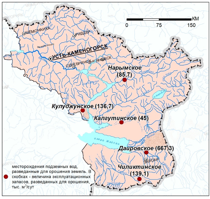
Карта МПВ, разведанных для ОРЗ на территории Восточно-Казахстанской области
In Kazakhstan, land reclamation is a pivotal strategy for diminishing the nation's reliance on inclement weather conditions and enhancing the predictability of vegetable and melon crop production. This approach is further instrumental in fostering stability in producing industrial crops, grain, forage crops, and livestock products. According to the optimal development scenario, it is projected that by 2040, all irrigated areas will be expanded to encompass 2,210,000 hectares, including 1,800,000 hectares designated for regular irrigation and 410,000 hectares allocated for limanic irrigation. This will ensure the domestic population's comprehensive fulfilment of agricultural product and livestock fodder requirements.
Within the administrative regions of Southern, Eastern and Western Kazakhstan, calculations of design irrigation areas were carried out for each of the WFs explored for irrigation based on the average value of the hydromodule that takes into account its flow rate for irrigation without taking into account losses in the irrigation network. The hydromodule defined by the results of study is typically 1.0 - 0.5 l/s per 1 ha for Central Asia and Kazakhstan. An average value of 0.7 l/s per 1 ha (0.0007 m3/s per 1 ha) was utilised for the calculations. Due to groundwater use, the total design area of irrigated lands was measured in thousands of hectares, in Southern Kazakhstan at 234.33, Eastern Kazakhstan at 54.74, and Western Kazakhstan at 10.84. The most significant areas of project irrigation of lands at the expense of groundwater are confined to the Zhetisu region (129.75 thousand ha).
The geoinformation system of exploitable reserves of WFs explored for irrigation was replenished with data on seven administrative provinces of Southern and Eastern Kazakhstan and on three WMBs of the study area.
Overall, the following results were achieved following the implementation of the program in 2023-2025:
The assessment of the current state of groundwater deposits explored for irrigation purposes was carried out on the basis of actual data obtained during regional expeditionary surveys involving the collection of groundwater and soil samples for chemical laboratory testing across all administrative oblasts of Kazakhstan. From an environmental perspective, the condition of the deposit areas is practically undisturbed. No subsidence of soils or ground surface has been identified. No processes of soil salinization and oppression of flora are observed. In sanitary terms, no probable foci of soil and groundwater contamination have been identified.
Potential possibility of groundwater use for irrigation in the future is justified by the values of predicted exploitable groundwater resources. The main resources of fresh groundwater with mineralization up to 1 g/l are concentrated in South Kazakhstan - about 59.4%; 13.8% - in East Kazakhstan; 13.2% - in North Kazakhstan; 7.1% - in Central Kazakhstan and 6.5% - in West Kazakhstan. The value of natural groundwater resources for the territory of Kazakhstan is 1215.8 m3/s or 38.34 km3/year, with an average module of 0.45 l/s 1 km2. Distribution of natural groundwater resources by regions are as follows: South Kazakhstan - 58.8%; East Kazakhstan - 15.0%; North Kazakhstan - 12.7%; West Kazakhstan - 7.0% and Central Kazakhstan - 6.5%.
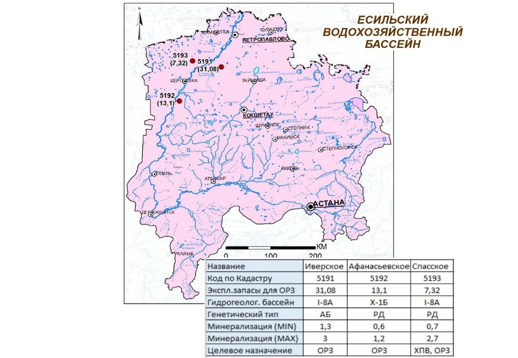
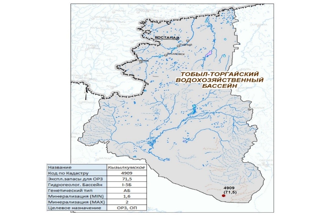
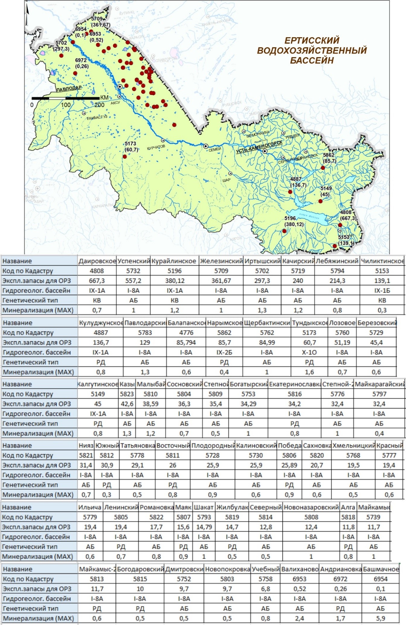
According to data from the Geology Committee of the Ministry of Industry and Construction of the Republic of Kazakhstan, 115 groundwater deposits with exploitable reserves (7,797 km3/year) have been explored for land irrigation in the Republic of Kazakhstan, including by region: Western -8 GWD (0.239); North – 50 GWD (1.115); Central – 10 GWD (0.154); East – 10 (1.208); South – 37 GWD (5.04).
Regional expeditionary studies conducted in 2023-2025 did not reveal any clear trends in the impact of climate change on groundwater resources or on the size of exploitable reserves in deposits explored for land irrigation. A slight decrease in water levels at deposits located in river valleys, alluvial fans, and foothill plains is due to the low-water period. All deposits explored for irrigation are practically unexploited and are not threatened with depletion. Groundwater contamination and potential sources of contamination have also not been identified.
|
|
To assess the security of exploitable reserves, the groundwater exploitable reserves security coefficient is used, which is the ratio of the total value of natural reserves and natural resources to the value of exploitable groundwater reserves. Practically all groundwater deposits explored for irrigation purposes in Kazakhstan are fully covered by natural resources, elastic or natural reserves for the entire estimated period of operation. In the current period, climatic changes in the groundwater level regime of individual deposits, due to low water years, will not affect the values of exploitable reserves of groundwater deposits explored for irrigation.
Water suitability for irrigation is determined on the basis of its chemical analysis by irrigation coefficients. Groundwater meets the requirements for irrigation water.
For each administrative oblast of the Republic, the status of irrigated land is described based on current data from the Ministry of Agriculture of the Republic of Kazakhstan. Ameliorative condition was assessed based on the results of hydrogeological and soil-reclamation works. The depth of occurrence and salinity of groundwater, the degree of salinity of the upper one-meter thickness of soils and subsoils were used as zoning indicators.
|
|
| |
Within administrative oblasts, calculations were made for each groundwater deposit explored for irrigation purposes to determine the prospective secured irrigation areas based on the average hydromodule value, taking into account its consumption for irrigation without considering losses in the irrigation network. For Central Asia and Kazakhstan, the hydromodule is usually in the range of 1.0 - 0.5 l/s per 1 ha. An average module value of 0.7 l/s per 1 ha (0.0007 m3/s per 1 ha) was used for the calculations. The total estimated area of irrigated lands due to groundwater use amounted to, thousand ha: for South Kazakhstan - 234.5; East Kazakhstan - 54.7 and West Kazakhstan - 10.8. North – 45.41; Central – 8.13. The largest promising areas for irrigation supplied by groundwater are located in the Zhetisu oblast – 129.8 thousand hectares.
The structure of the GWD DB, surveyed for land irrigation, has been developed. The system has been populated with GWD data for all oblasts and water economic basins where groundwater deposits for irrigation have been explored. The GWD DB includes both primary data and the results of its processing, which involves structuring it - converting semantic information into tabular form, dividing cartographic information into layers, assessing data completeness, etc. Information on GWDs explored for LI is placed in document, semantic and graphical databases. The map of hydrogeological zoning of Kazakhstan on conditions of land irrigation with groundwater is presented as archival data in the GIAS.
List of published works
2024:
In foreign publications--1:
1.Evgeny Sotnikov, Zarina Inelova, Oxana Miroshnichenko, Lyudmila Trushel, Dauren Umbetaliyev, and Ilan Shakibayev. Numerical Models for Solving Water Problems of Irrigated Agriculture in South-East Kazakhstan// ES Food&Agroforestry, 2024, Volume 18, DOI: 10.30919/esfaf1288, p.1-49, Scopus Percentile 97
In republican publications -7
1.Monograph: 'Resource potential of groundwater in Western Kazakhstan for the development of irrigated agriculture'// under the general editorship of Absametov M.K., 'Smart University Press', 2024, 80 p.
2.D.S.Sapargaliyev, V.М.Mirlas, Y.Z.Murtazin, V.А.Smolyar. «Hydrogeological study and assessment of the groundwater resources in the Cretaceous deposits of the Zhem Basin»// Горный журнал Казахстана, 2024, выпуск 24, стр. 35-42 https://doi.org/10.48498/minmag.2024.226.2.004
3.S.R. Tazhiyev, E.Zh. Murtazin, L.Yu. Trushel. Prospects for the use of groundwater deposits in the Kazakh part of the Kyrgyz Alatau foothills for irrigation and domestic and drinking water supply in rural settlements of the Zhambyl region.//Geography and water resources, №2, 2024 г., p.143-151, https://doi.org/10.55764/2957-9856/2024-2-143-151.20
4.T.A.Rakhimov, A.T.Toktar, A.A. Nurgazieva. Prospects for the use of groundwater in the southern part of the Kerbulak deposit for irrigation//Engineering Journal of Satbayev University, Volume 146 (2024), Issue 1, P.25-32, https://doi.org/10.51301/ejsu.2024.i3.04
5.Zh.A Onglassynov, L.V. Shagarova, М.М. Muratova. Assessment of spectral indices variations in areas with favourable hydromeliorative conditions of the Maktaaral irrigation massif//Engineering Journal of Satbayev University, Volume 146 (2024), Issue 5, 45-53, https://doi.org/10.51301/ejsu.2024.i5.06
6.Onglassynov Zh.A., Sotnikov Е.V., Miroshnichenko О.L., Muratova М.M. Mathematical model of hydrogeological conditions of irrigated lands of the Maktaaral massif. // 3i: intellect, idea, innovation, № 4, 2024 г., p.119-127, https://doi.org/10.52269/22266070_2024_4_119
7. K. Adenova, E.Zh. Murtazin, O.L. Miroshnichenko. Assessment of the state and quality of hydrogeochemical indicators of artesian groundwater in the Zhambyl region. // Geography and water resources, https://doi.org/10.55764/2957-9856/2024-4-75-83.41, № 4, 2024, С.77-82
Intellectual property objects registered in the National Institute of Intellectual Property of the Republic of Kazakhstan were received:
1.Copyright certificate № 42833 from 12 February 2024: Smolyar V.A., Trushel L.Y. ‘Hydrogeochemical map of groundwater of the Republic of Kazakhstan’
2.Copyright certificate № 43022 from 19 February 2024: Smolyar V.A., Trushel L.Y. Map of hydrogeological zoning of the territory of the Republic of Kazakhstan at a scale of 1:5 000 000’
3.Copyright Certificate No. 43105 dated 21 February 2024: Smolyar V.A., Kikhtev V.A. ‘Map of current state and prospects of groundwater use for irrigation of the Republic of Kazakhstan lands at a scale of 1:5 000 000’
2025:
In foreign publications -6:
1.Dinara Adenova, Daniyar Sapargaliyev, Janay Sagin, Malis Absametov, Yermek Murtazin, Vladimir Smolyar. Assessing groundwater and soil quality in West Kazakhstan amid climate impacts and oil industry contamination risks// Scientific Reports, №15, Article number: 6663 (2025), P.1-19, doi.org/10.1038/s41598-025-90033-z, Scopus Percentile 89
2.D.Sapargaliyev, Ye.Murtazin, V.Mirlas, V.Smolyar, Y.Anker. MODFLOW Application for Exploitable Groundwater Resource Assessment of the Zhem Artesian Basin Aquifer Complex, Kazakhstan// Applied Sciences, 2025, 15, 5443, https://doi.org/10.3390/ app15105443, P.1-37 Scopus Percentile 79
3.Murtazin Y., Kulagin V., Mirlas V., Anker Y., Rakhimov T., Onglassynov Z., Rakhimova V. Integrated Assessment of Groundwater Quality for Water-Saving Irrigation Technology (Western Kazakhstan).// Water. 2025, 17, 1232. https://doi.org/10.3390/ w17081232 с.1-36, Scopus Percentile 79
4.Onglassynov Z., Berndtsson R., Rakhimova V., Rakhimov T., Jabassov A., Rakhmetov I., Muratova M., Tussupova K. GIS-Based MultiCriteria Assessment of Managed Aquifer Recharge (MAR) Zones Using the Analytic Hierarchy Process (AHP) Method in Southern Kazakhstan// Water, 2025, 17, 2774. https://doi.org/10.3390/w17182774 Scopus Percenti.
5.Evgeny Sotnikov, Zhuldyzbek Onglassynov, Kanat Kanafin, Ronny Berndtsson, Valentina Rakhimova, Oxana Miroshnichenko, Shynar Gabdullina, Kamshat Tussupova. Identifying Fresh Groundwater Potential in Unconfined Aquifers in Arid Central Asia: A Remote Sensing and Geo-Information Modeling Approach. Water 2025, 17, 2985. https://doi.org/10.3390/w17202985 , p.1-34, Scopus, Percentile79
6.M.Absametov, D.Umbetaliev, V.Kulagin, T.Rakhimov, V.Mirlas, A.Ismagulova, V.Rakhimova. Optimizing irrigation efficiency: a case study of the Bakbakti Rice System in Akdala Massif//Frontiers in Water, 2025, V.7, №1650089, 22 P., doi: 10.3389/frwa.2025.1650089, Scopus, Percentile 74
In republican publications -8
1.Monograph: “Resource potential of groundwater in Southern and Eastern Kazakhstan for the development of irrigated agriculture”// edited by M.K. Absametov, «Smart University Press», 2025, 230 p.
2.Monograph: “Resource potential of groundwater in Northern and Central Kazakhstan for the development of irrigated agriculture”// edited by M.K. Absametov, «Smart University Press», 2025, 146 p.
3.V.A.Smolyar, D.K.Adenova, V.S. Rakhimova, D.S.Sapargaliev. Assessment of irrigated agriculture availability due to groundwater deposits explored for land irrigation in Southern and Eastern Kazakhstan// Geography and water resources, №2, 2025, с.64-72, https://doi.org/10.55764/2957-9856/2025-2-64-72.21
4.M.Absametov, A.Ismagulova, V.Mirlas, V.Kulagin, D.Umbetaliev, T.Rakhimov, V. Rakhimovа. Monitoring of the water and salt balance of the Bakbakty rice irrigation system under reuse of collector-drainage water for irrigation// Engineering Journal of Satbayev University, Volume 148 (2025), Issue 3, p.40-47, https://doi.org/10.51301/ejsu.2025.i3.06
5.M.K.Absametov, V.D.Vyalov, D.К.Adenova, A.М.Baikadamova. Creation of a complex for the production of heat and electric power based on the geothermal waters of the Zharkent depression// Engineering Journal of Satbayev University, Volume 147 (2025), Issue 4, p.37-42. https://doi.org/10.51301/ejsu.2025.i4.06
6.V.A.Smolyar, D.K.Adenova, Ye.Zh.Murtazin, T.A.Rakhimov. Forecast of potential changes in exploitable groundwater reserves under the influence of natural and anthropogenic processes at deposits explored for irrigation// Geography and water resources, №3, 2025, c.34-41, https://doi.org/10.55764/2957-9856/2025-3-34-41.30
7.И.К.Рахметов, Ә.Т.Тоқтар, А.А.Нургазиева. Оценка современного состояния месторождений подземных вод Восточного Казахстана, разведанных для орошения// География и водные ресурсы, №3, 2025, c.58-68, https://doi.org/10.55764/2957-9856/2025-3-58-68.32
8.Оңласынов Ж.Ә., Шагарова Л.В., Муртазин Е.Ж., Муратова М.М. Идентификация зон потенциала грунтовых вод территории улытауской области с использованием методов ГИС и АНР// “3i: intellect, idea, innovation - интеллект, идея, инновация”. — 2025. — № 4. ( Часть I ) — С. 138-146. https://doi.org/10.52269/NTDG2541138.
The following intellectual property rights have been registered with the National Institute of Intellectual Property of the Republic of Kazakhstan:
1.Copyright Certificate No. 53663 dated January 20, 2025: V. A. Smolyar, V. A. Kiktev. "Map of Groundwater Deposits in the Republic of Kazakhstan, Scale 1:2,500,000."
2.Copyright Certificate No. 53658 dated January 20, 2025: V. A. Smolyar, R. K. Ayazbayev. "Map of Water Management Zoning of the Republic of Kazakhstan. Water Resource Potential of Water Management Basins, Scale 1:5,000,000."
Item |
Full name, education, degree, academic rank |
Principal place of work, position |
Hirsch index, Researcher ID, ORCID, Scopus Author ID |
1. |
Murtazin Ermek Zhamshitovich, higher education, KazPTI named after Lenin, major: Hydrogeology and Engineering Geology, |
Ahmedsafin Institute of Hydrogeology and Environmental Geoscience LLP (hereinafter referred to as the IHEG), Deputy Director of Research |
Hirsch index 3 (Scopus), |
2. |
Sagin Janay (Sagintayev Zhanay, Sagin Jay), higher, Western Michigan University (USA), PhD in Geosciences |
Foreign scientist, |
Hirsch index 13, |
3. |
Absametov Malis Kudysovich, higher, KazPTI named after V.I. Lenin, major: Hydrogeology and Engineering Geology, Doctor of Sciences (Geol.-Min.), Professor, Academician of the NAS RK |
IHEG, Director |
Hirsch index 3, |
4. |
Rakhimov Timur Aytkalievich, higher, KazNRTU named after K.I. Satbayev, major: Hydrogeology and Engineering Geology, PhD |
IHEG, Head of the Laboratory of Regional Hydrogeology and Ecology |
Hirsch index 2, |
5. |
Mukhamedzhanov Murat Abikenovich, higher, Mining and Metallurgical Institute of Kazakhstan, major: Hydrogeology and Engineering Geology, Doctor of Sciences (Geol.-Min.), Corresponding Member of the NAS RK |
IHEG, CR of the Laboratory of Regional Hydrogeology and Geoecology |
|
6. |
Toktar Aliya Toleubaykyzy, higher, S.Ordzhonikidze Russian State University for Geological Prospecting, Moscow, |
IHEG, R of the Laboratory of Regional Hydrogeology and Geoecology |
|
7. |
Nurgazieva Asel Azatkalievna, higher, KazNRTU named after K.I. Satbayev, major: Hydrogeology and Engineering Geology |
IHEG, R of the Laboratory of Regional Hydrogeology and Geoecology |
Hirsch index 3 |
8. |
Kiktev Valentin Aleksandrovich, higher, KazPTI named after V.I. Lenin, Major: Hydrogeology and Engineering Geology |
IHEG, Leading Engineer of the of the Laboratory of Regional Hydrogeology and Geoecology |
ORCID: 0009-0009-8556-9493 |
9. |
Sapargaliev Daniyar Serikovich, higher, KazNRTU named after K.I. Satbayev, major: Hydrogeology and Engineering Geology, Master's degree, doctoral student |
IHEG, Executive Secretary for Innovation |
|
10. |
Kanafin Marat Utegenovich, higher, KazPTI named after V.I. Lenin, major: Hydrogeology and Engineering Geology |
IHG, Leading Engineer of the of the Laboratory of Regional Hydrogeology and Geoecology |
|
11. |
Zheksembaev Erkebulan Shektibaevich, higher, KazNRTU named after K.I. Satbayev, major: Geology and Exploration of Mineral Deposits, PhD |
IHEG, SR of the Hydrogeological and Geoecological Processes Modeling Laboratory |
Hirsch index 0,
|
12. |
Nurmukhambetova Bakhyt Isakhanovna, higher, Al-Farabi KazNU, major: chemistry, Candidate of Chemical Sciences |
IHEG, Scientific Secretary |
|
13. |
Adilova Lyaila Maratovna, higher, Abai Kazakh National Pedagogical University, major: Chemistry-Biology |
IHEG, Head of the Test Sector of the Laboratory of Chemical and Analytical Studies |
|
14. |
Itemen Nurbol Mergenbayuly, higher, KazNRTU named after K.I. Satbayev, major: Hydrogeology and Engineering Geology, Master's degree, doctoral student |
IHEG, R of the Industrial and Geothermal Water Laboratory |
Hirsch index 0, |
15. |
Chensizbaev Daniyar Borashuly, higher, KazNRTU named after K.I. Satbayev, major: Hydrogeology and Engineering Geology, Master's degree, doctoral student |
IHEG, JR of the Industrial and Geothermal Water Laboratory |
|
16. |
Iskanderov Rustam Ruslanovich, higher, KazNRTU named after K.I. Satbayev, major: Hydrogeology and Engineering Geology, Master's degree |
IHEG, JR of the Industrial and Geothermal Water Laboratory |
Hirsch index 2, |
17. |
Kulbekova Roza Abdizhapparovna, higher, Al-Farabi KazNU, major: chemistry, Master in Environmental Sciences. |
IHEG, JR of the Laboratory of Chemical and Analytical Studies |
Hirsch index 2, |
18. |
Nurpeisov Rauan Akhmetovich, higher, |
IHEG, Leading Engineer of the Industrial and Geothermal Water Laboratory |
|
19. |
Bagiman Orken, higher, Sofia University of Mining and Geology, major: Hydrogeology and Engineering Geology |
IHEG, Leading Engineer of the of the Laboratory of Regional Hydrogeology and Geoecology |
|
20. |
Yusupov Marsel Nurmukhamedovich Major: Electrical Engineer |
IHEG, Equipment Engineer for the Laboratory of Chemical and Analytical Studies |
|
21. |
Koshpanova Kalamkas Eskatkyzy, higher, KazNRTU named after K.I. Satbayev, major: Chemical Technology of Inorganic Substances, Master of Science in Engineering and Technology. |
IHEG, Leading Engineer of the Laboratory of Chemical and Analytical Studies |
ORCID: 0000-0002-5230-0545 |
22. |
Ermek Ultu, |
IHEG, Category 1 Engineer for the Laboratory of Chemical and Analytical Studies |
|
23. |
Lee Bin-Chin Olga Sergeevna, |
IHEG, Category 1 Engineer for the Laboratory of Chemical and Analytical Studies |
|
24. |
Baisakalova Perizat Asylbekovna, |
IHEG, Category 1 Engineer for the Laboratory of Chemical and Analytical Studies |
|
25. |
Umarov Timur Sadykovich, higher, Kazakh Leading Architecture and Civil Engineering Academy, major: Construction, Master's degree in Oil and Gas Engineering |
IHEG, Category 1 Engineer of the Industrial and Geothermal Water Laboratory |
|
26. |
Kirilova Vera Ivanovna, Tashkent Hydrometeorological Technical School, Major: Meteorologist |
IHG, Category 2 Engineer for the Laboratory of Chemical and Analytical Studies |
|
27. |
Smolyar Vladimir Aleksandrovich, higher, KazPTI named after V.I. Lenin, major: Hydrogeology and Engineering Geology, Cand. Sci. (Geol.-Min.) |
IHEG, CR of the Laboratory of Regional Hydrogeology and Geoecology |
Hirsch index 1, ORCID: 0000-0003-4790-339X |
28. |
Muratkhanov Dauren Bolatuly, higher, KazNRTU named after K.I. Satbayev, major: Water Resources and Water Use, Master of Agricultural Sciences |
IHEG, JR of the Laboratory of Regional Hydrogeology and Geoecology |
Hirsch index 1, |
29. |
Rakhmetov Isa Kanatovich, higher, KazNRTU named after K.I. Satbayev, major: Water Resources and Water Use, Master of Engineering in Hydrogeology and Engineering Geology |
IHEG, JR of the Laboratory of Regional Hydrogeology and Geoecology |
Hirsch index 2, |
30 |
Dzhabasov Abay Maratovich, |
IHEG, Head of the Groundwater Resources Laboratory |
Hirsch index 0, |
31. |
Livinsky Jury Nikolaevich, |
IHEG, LR of the Groundwater Resources Laboratory |
Hirsch index 3, |
32. |
Ermenbay Aray Musakyzy, higher, KazNRTU, named after K.I. Satbayev major: Hydrogeology and Engineering Geology |
IHEG, R of the Groundwater Resources Laboratory |
Hirsch index 3, |
33. |
Zhakibaeva Aygerim Zhanatovna, higher, KazNRTU named after K.I. Satbayev, major: Geology and Exploration of Mineral Deposits, Master of Science in Hydrogeology and Engineering Geology, doctoral student |
IHEG, JR of the Groundwater Resources Laboratory |
|
34. |
Bazarbaeva Gulnara Orumbaevna, higher, KazPTI named after V.I. Lenin, Major: Hydrogeology and Engineering Geology |
IHEG, JR of the Groundwater Resources Laboratory |
|
35. |
Sembaev Daulet Birzhanuly, higher, KazNRTU named after K.I. Satbayev, major: Geology and Exploration of Mineral Deposits, Master of Engineering in Hydrogeology and Engineering Geology |
IHEG, Leading Engineer of the Groundwater Resources Laboratory |
Hirsch index 0, |
36. |
Onlasynov Zhuldyzbek Alikhanuly, higher, KazNRTU |
IHEG, Head of the Laboratory of GIS Technologies and Earth's Remote Sensing |
Hirsch index 1, |
37. |
Rakhimova Valentina Stanislavovna, higher, KazNRTU |
IHEG, SR of the Hydrogeological and Geoecological Processes Modeling Laboratory |
Hirsch index 1 |
38. |
Malau Rakhima Suleymanovna, higher, Kazakh National Agrarian University, major: Water Resources and Water Use, Master of Agricultural Sciences in Water Resources and Water Use |
IHEG, R of the Laboratory of GIS Technologies and Earth's Remote Sensing |
Researcher ID: AFH-9871-2022 |
39. |
Akynbaeva Madina Zhakypzhanovna, higher, Al-Farabi KazNU, |
IHEG, JR of the Laboratory of GIS Technologies and Earth's Remote Sensing |
|
40. |
Muratova Mira Muratovna, higher, Almaty State University named after Abai, major: Chemistry-Biology |
IHEG, Leading Engineer of the Laboratory of GIS Technologies and Earth's Remote Sensing |
Hirsch index 2, |
39. |
Usenov Dosbol Nurkenuly, higher, Al-Farabi KazNU, major: Cartography, Master's degree |
IHEG, Category 1 Engineer of the Laboratory of GIS Technologies and Earth's Remote Sensing |
ORCID: 0000-0001-9814-0164 |
40. |
Sotnikov Evgeny Vladimirovich, higher, KazNRTU named after K.I. Satbayev, major: Geology and Exploration of Mineral Deposits, PhD |
IHEG, Head of the Hydrogeological and Geoecological Processes Modeling Laboratory |
Hirsch index 1, |
41. |
Trushel Lyudmila Yurievna, higher, KazPTI named after V.I. Lenin, major: Hydrogeology and Engineering Geology, Cand. Sci. (Geol.-Min.) |
IHEG, CR of the Hydrogeological and Geoecological Processes Modeling Laboratory |
Hirsch index 4, |
42. |
Miroshnichenko Oksana Leonidovna, higher, KazNU named after S.M.Kirov, major: |
IHEG, LR of the Hydrogeological and Geoecological Processes Modeling Laboratory |
Hirsch index 4, |
43. |
Adenova Dinara Kiyzbaevna, higher,KazNRTU named after K.I. Satbayev, major: Hydrogeology and Engineering Geology, PhD |
IHEG, SR of the Hydrogeological and Geoecological Processes Modeling Laboratory |
Hirsch index 3, |
44. |
Tazhiev Sultan Rysniyazovich, higher, KazNRTU named after K.I. Satbayev, major: Water Resources and Water Use, Master of Agricultural Sciences in Water Resources and Water Use |
IHEG, R of the Hydrogeological and Geoecological Processes Modeling Laboratory |
Hirsch index 1, |
45. |
Myrzagaziyeva Rashilya Mubarakovna |
IHEG, Leading Engineer |
|